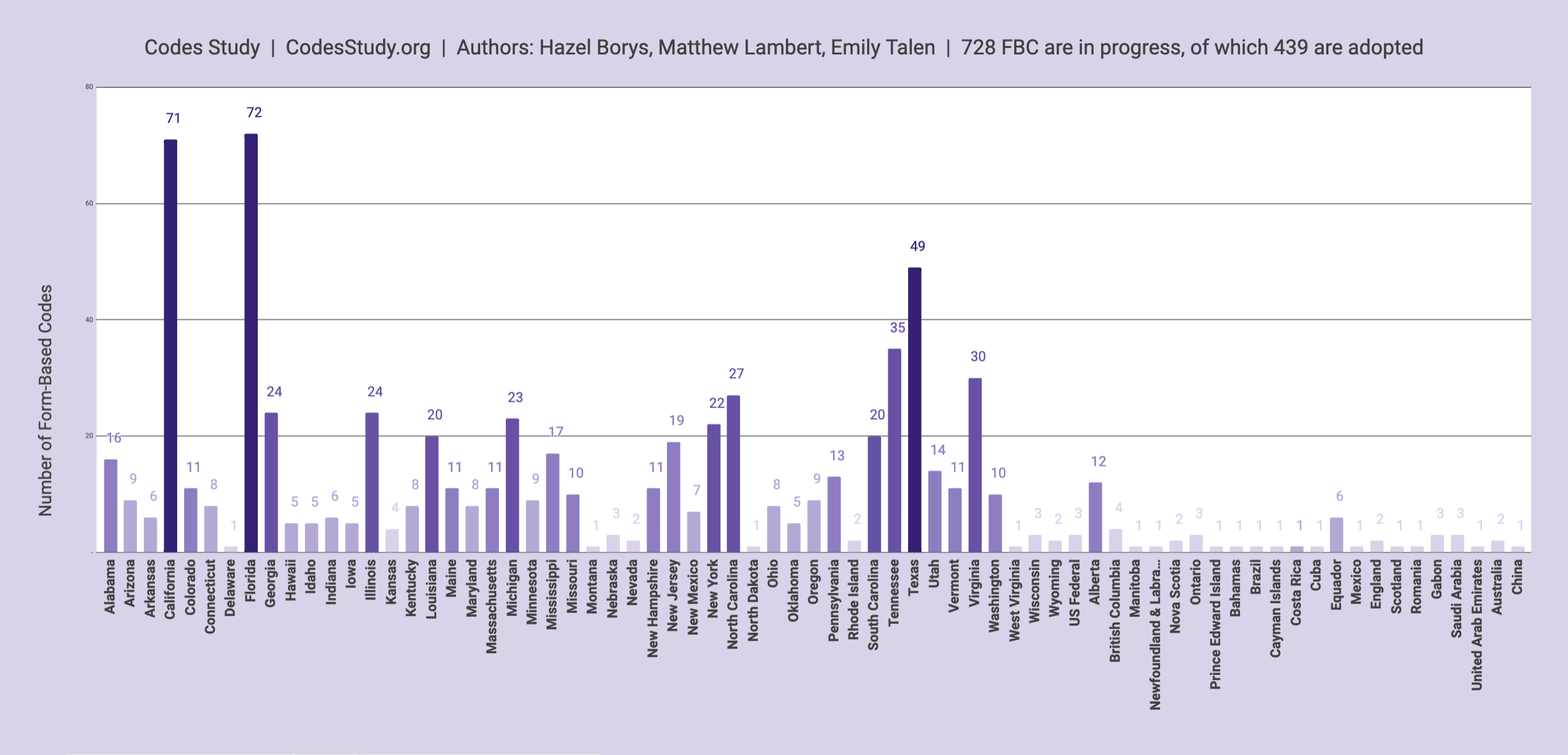
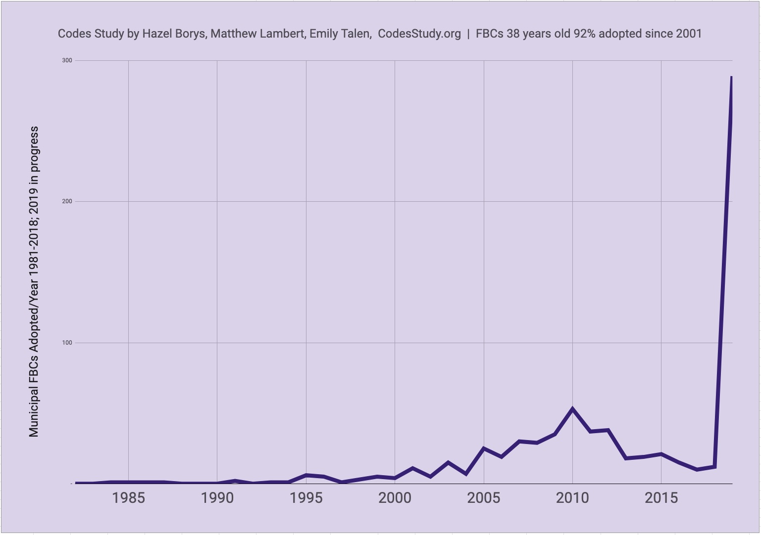
 The Codes Study is a collaborative effort led by Hazel Borys, Emily Talen, and Matthew Lambert, and contributed to by many public and private planners, tracking the prevalence of form-based codes worldwide. As of June 2019, we’ve tracked 728 codes that meet criteria established by the Form-Based Codes Institute (FBCI), as well as an additional 17 form-based guidelines. 439 of these are adopted, with others in progress. Even though form-based codes are 38 years old, 91% have been adopted since 2001.
Why form-based codes? Because our current laws tend to separate where we live from where we work, learn, and shop, and insist on big, fast roads to connect them all. Roads that are unfriendly to pedestrians, cyclists, and transit. As a result, North Americans spend more hours in their cars than anyone on earth, and a growing number of communities are working to do something about it.
Cities and towns are using form-based codes to reverse these trends. Big city adopters include Miami, Nashville, Buffalo, Dallas, Ft. Worth, Denver, Albuquerque, El Paso, Memphis, Baltimore, Tulsa, Portland, Cincinnati, Philadelphia, Los Angeles, San Diego, Austin, Chattanooga, Atlanta, Jacksonville, Calgary, Abu Dhabi, Dammam. And because the unit of urban design is the neighborhood, form-based codes have also been applied to as small as 100-person populations and 35 acres. Check out Code Score to see their return on investment.

 It's a tremendous shift in business as usual, reflecting proactive, locally-driven efforts around the world to improve quality-of-life and become more economically competitive. And like any organically-emerging sea change, access to up-to-date information -- what other communities are doing and how they're doing it -- is what keeps things moving.
That's what The Codes Study is all about.
The Codes Study tracks SmartCodes, other Transect-based codes, and other form-based codes that meet FBCI criteria:
- Is the code's focus primarily on regulating urban form and less on land use?
- Is the code regulatory rather than advisory?
- Does the code emphasize standards and parameters for form with predictable physical outcomes (build-to lines, frontage type requirements, etc.) rather than relying on numerical parameters (FAR, density, etc.) whose outcomes are impossible to predict?
- Does the code require private buildings to shape public space through the use of building form standards with specific requirements for building placement?
- Does the code promote and/or conserve an interconnected street network and pedestrian-scaled blocks?
- Are regulations and standards keyed to specific locations on a regulating plan?
- Are the diagrams in the code unambiguous, clearly labeled, and accurate in their presentation of spatial configurations?
The Codes Study also tracks major initiatives and guidelines that may assist in the formulation of form-based codes. While these may not meet FBCI criteria and do not count toward numbers of SCs, TBCs, and FBCs, they are listed as FB Guidelines.
Click links within the full Codes Study to go to project pages and to view codes. If you have updates or additions, please let us know and we'll include in the next update.
Collaborative Google Maps are part of the Codes Study:
SmartCodes Adopted | SmartCodes in Progress | Other Form-Based Codes
As you add your work, please use purple markers for other form-based codes, green markers for SmartCodes adopted, and yellow markers for SmartCodes in progress.
The Codes Study generally does not track developer-driven form-based codes, however these collaborative maps detail Traditional Neighborhood Developments of comparable character: Eastern US | Western US | Canada
As you add your work, please use blue markers for greenfield development and turquoise for infill.
Codes Study by Hazel Borys, Emily Talen, and Matthew Lambert is licensed under a Creative Commons Attribution-NonCommercial-ShareAlike 3.0 Unported License. Based on a work at https://placemakers.com/how-we-teach/codes-study/.


[…] we updated and republished the Codes Study last week, I was deeply encouraged by all of you who expressed support. Thank you! From Rome to […]
[…] Form-Based Codes Study […]
[…] Regardless of why you’re looking to build community, development patterns matter. If you’ve got historic areas, recognize their embedded wisdom and work to preserve them. And for new growth, take on the fact that, across the continent, many of our most admired, human-scaled practices are currently illegal. Reform your current zoning or replace it with a more character and context-sensitive form-based code. […]
[…] zoning that stands in their way. In response, form-based codes have emerged as a useful remedy, effectively legalizing community visions worldwide and serving as a bridge between their current conditions and the goals they’re trying to […]
[…] experience, its rules and regulations will govern the functional design details that are found in a form-based code — issues such as fenestration, build-to lines, entrance height, […]
[…] problem involves a community that is focused on generating a specific placemaking tool such as a form-based code. The advocates in the community (who are often well-versed in placemaking issues) try to […]
[…] Borys and Emily Talen just released their Codes Study for November. This study tabulates the use of form-based codes (FBC) across the country in order to […]
[…] and that community begins investing in its own future by exploring ideas like downtown development, zoning reform or suburban retrofitting, it’ll surely feel to her like one step closer to home. I can see her […]
[…] and development regulations and the premier tool for maintaining and fostering community character. 433 communities have taken this step, and many more are laying the groundwork to do so […]
[…] development into more productive patterns for economies, society, and the environment by using form-based codes. Within these character-based laws, Transfer of Development Rights (TDRs) are sometimes employed to […]
[…] hometown of Huntsville, Alabama is joining hundreds of others in contemplating a form-based code to make it a better place to live for people of all ages, however at present it’s predominantly […]
[…] resilience, or else makes for a lonely, disconnected, nowhere. Some towns and cities are using form-based codes to help reconnect people with each other and the places they call […]
[…] with your crowdsourced input, I started the Codes Study. A few years later, Dr. Emily Talen joined me as we continue to look at laws that allow the […]
[…] to a spate of ills — ill health, ill economies, and ill environments. We looked at some of the places that are reversing those use-separated laws of the last 80 years, allowing a mixture of compatible […]
[…] the metrics wrong. While everything else about the code may look right, and even pass the test for FBCI Criteria, a hybrid-gone-wrong can originate with something as simple as street […]
[…] design. However, they have been slow to take hold among municipal governments; there are currently about 280 adopted form-based code ordinances in the U.S., impacting just 3% of the national population. Many of the […]
[…] design. However, they have been slow to take hold among municipal governments; there are currently about 280 adopted form-based code ordinances in the U.S., impacting just 3% of the national population. Many of the […]
[…] I recommend our frequent blogs on upgrading land-use laws to enable walkable places along with the Codes Study, which tracks the leaders in this field. If your interested in reindustrialization, check out these […]
[…] a little New Year’s inspiration, here’s a list of the places getting real by changing their laws to reflect the character of their communities. And getting the significant […]
[…] That neighbourhood structure itself is one of the things that make this park function so beautifully. The 30 to 100 children from 6 to 16 years old who visit the park everyday most likely get there mainly on foot and bicycle. That’s because the park is within the immanently walkable Prenzlaur Berg neighbourhood that we discussed on Monday. As you know, we define the pedestrian shed as a 5-minute walk or quarter-mile from the centre to edge of a neighbourhood, with a walkable neighbourhood containing most of your daily needs. Similarly, the playshed is the eighth-mile radius, with every residence within 1000′ of a playground. If I didn’t have a deadline calling, I’d illustrate it for Prenzlaur Berg. To learn more about playsheds, check out the form-based SmartCode and manual. And to see who’s legally requiring playsheds, check out the Codes Study. […]
[…] if you’d like to join me at looking at the 584 cities who are upping their game, check out the Codes Study. This is a collaboration by a lot of people over the last twelve years, and it’s always a work in […]
[…] he also warns that when using the Transect, we must stay lean, “Form-based codes pencil when we allow the alley to be built to driveway standards, not road or highway standards. […]
[…] urban places accelerate the movement. Form-based codes are in the works to deliver both for over 45 million people […]
[…] remains this: urban design is not an abstraction. Urbanists aren’t talking in tongues about form-based codes, ground floor frontage and Gehl Door Average for no reason. When buildings are designed right, with […]
[…] remains this: urban design is not an abstraction. Urbanists aren’t talking in tongues about form-based codes, ground floor frontage and Gehl Door Average for no reason. When buildings are designed right, with […]
[…] falls away to auto-centric forms that are indistinguishable from any other city in North America. A form-based development bylaw could help suburban neighbourhoods re-inject local […]
[…] in the SmartCode! This thing really works, people! It’s being adopted and used in more and more communities all around the world every day, and it’s doing its job – making walkable places! We need to adopt the […]
[…] and profit. A wide variety of interventions are underway to try to reverse this. Some of these are extensive, and others could be called highly effective baby […]
[…] Nov 252015 November 25, 2015 Auto Use, Bicycles, Community Culture, Design Review, Form Based Zoning, Livability, Mixed Use, Moderate Density, Municipal Services, Placemaking, Planning, Public Spaces, Smart Growth, Sprawl, Street Trees, Walkable Community, Zoning The OCPG has come to realize that the difficulty with density and parking and other issues relating to a walkable Oxnard Boulevard in our downtown and corridor areas is that our current zoning does not allow true urban placemaking. For instance, current Oxnard zoning in the downtown allows 39 units per acre…which means that the living units must be 3 and 4 bedrooms. We need higher density to accommodate the empty-nesters, Millennials and others who are interested in living an urban lifestyle and want singles or 1 bedroom units. Form Based codes allow a broader range of options in specific overlay areas. Zoning in Oxnard’s residential areas will not change. Form based codes are generally applied in very specific overlay areas do not replace existing zoning. Here is a copy of the Form Based Code section of our Resources page – click the Resources tab above to view all our great place-making and urban design links. Form Based Codes “Why form-based codes? Because our current laws tend to separate where we live from where we work, learn, and shop, and insist on big, fast roads to connect them all. Roads that are unfriendly to pedestrians, cyclists, and transit. As a result, North Americans spend more hours in their cars than anyone on earth, and a growing number of communities are working to do something about it.” [ PlaceMakers.com ] […]
[…] PlaceMakers colleague Hazel Borys and Arizona State University’s Emily Talen have been tracking the adoption of form-based codes worldwide. As of early 2015, they had documented nearly 600 codes incorporating form-based criteria, over […]
[…] PlaceMakers colleague Hazel Borys and Arizona State University’s Emily Talen have been tracking the adoption of form-based codes worldwide. As of early 2015, they had documented nearly 600 codes incorporating form-based criteria, over […]
[…] that build social capital and local resilience, or makes for a lonely, disconnected, nowhere. Form-based codes have been used to define the public realm, to create gathering places and to help reconnect people […]
[…] U.S. Others are in progress. For a map of the cities that have implemented FBC’s, you can visit http://www.placemakers.com/how-we-teach/codes-study/. Scroll down through the article to the heading “Collaborative Google Maps.” There you will […]
[…] Perception and Zoning. There are all sorts of reasons for the current retail imbalance that has created dark and under-performing storefronts in the heart of second tier cities, and some of it has to do with perception. Retailers are biased against locating in poor areas, even though the spending power per acre of poor neighborhoods is usually significantly greater than the suburbs because of greater density. Adding to perception problems is the very real problem of land use, which often favors the suburbs. We’ve blogged extensively about how to level the playing field as well as pointing to the places that are upgrading zoning practices. […]
[…] down to our zoning codes, which are predominately framed around driving. Here’s to all of the places that are changing the rules to get moving and put a little spring in our […]
[…] 1981, approximately 600 form-based codes (FBCs) have been prepared for communities across the US, and 362 of them have been adopted. Most of the […]
[…] to change a regulatory process with such engrained momentum. However, the adoption of FBC’s has grown exponentially in the last five years. Hybrid codes, that strategically overlay form-based requirements in […]
[…] and Denver. Many other cities and towns have adopted FBCs for portions of the municipality—the Codes Study counts 362. The Green Code, like other form codes, focuses on regulating urban form rather than […]
[…] all this with changes to zoning laws to enable walkable, healthy, nature-rich places and looked at who’s getting it done at […]
[…] change your suburban nation into a more walkable, bikable place. Make sure you add your work to the Codes Study or let us know about it in the comments […]
[…] the proliferation of form-based codes and rejection of parking minimums gaining steam, it’s clear there is demand for change. Towns […]
[…] το Ινστιτούτο Κωδικών Βασισμένο σε Φόρμες εντόπισε 439 κώδικες βασισμένοι σε διατομές που είχαν υιοθετηθεί…. Σαφώς, περισσότερες κοινότητες δεν ασπάζονται αυτή […]